
WATERFALL NOTE · RURAL HALF DAY
Tad Soung Waterfall
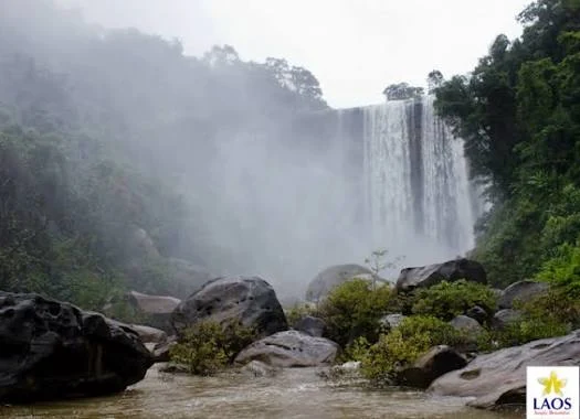
Tad Soung is the longer waterfall chapter: rural approach, lower falls, a moderate climb or road route to the top, and an escarpment whose view remains part of the reward even when controlled flow is low.
- 01The lower falls and the top are not the same visit
- 02The dam means a dry cliff can still be a real Tad Soung day
- 03The view is the reward — the edge is not a photo platform
- 04Give the countryside enough time instead of squeezing in another distant stop
Tad Soung is the half day. Let the road, climb and escarpment count as part of it.
01 · TWO APPROACHES
The lower falls and the top are not the same visit
Visit Tad Lo has locally checked two practical ways to build the route. From the village, the lower part of Tad Soung is roughly four kilometres away and can be reached on foot. From there, a renovated trail climbs between the lower and upper sections with about 80–100 metres of ascent. Travellers who do not want that climb can continue roughly another four kilometres by road and reach the upper access by motorbike or vehicle. The distinction is worth understanding before departure: typing one pin into a map can leave you at the wrong level of a tall waterfall. If you are walking, treat the approach and climb as the activity. If you are riding, decide whether you actually want the lower section, the top, or both before parking.
Choose lower falls, trail, top — or all three — before the road chooses for you.
02 · A CONTROLLED FLOW
The dam means a dry cliff can still be a real Tad Soung day
Tad Soung is season-sensitive, but rainfall is not the only variable. Local guidance notes that an upstream dam controls the flow, so the appearance of the waterfall can change even when the wider weather seems predictable. In the dry season the cascade may be reduced dramatically or even appear almost dry, while the panorama from the escarpment can remain worth the outing. Rainier conditions can make the falls much more impressive but also make the trail, lower access and exposed edges more serious. Old blogs sometimes publish precise valve-opening times; those should not be treated as a current timetable. The useful information is simply that flow is managed and can change. Ask locally before leaving if seeing a strong waterfall is the main reason for your trip.
At Tad Soung, water volume is partly weather and partly infrastructure.
03 · THE ESCARPMENT
The view is the reward — the edge is not a photo platform
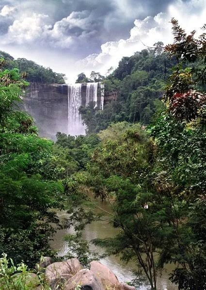
The upper section opens onto a broad rural landscape and is often the part travellers remember even when the flow is low. It also introduces height and exposed edges that do not exist in the same way at Tad Hang. Keep distance from the lip, especially on wet ground, and do not step onto a slick slab simply because an older photograph was taken there. The climb itself is moderate rather than technical, but heat, mud and the return distance can make the half-day feel larger than the elevation figure suggests. Shoes with grip, drinking water and enough daylight matter more than specialised hiking gear.
Tad Soung is the half day. Let the road, climb and escarpment count as part of it.
04 · BUILD THE HALF DAY
Give the countryside enough time instead of squeezing in another distant stop
Tad Soung works best as the main outing of a morning or afternoon. Walking from Tad Lo turns the route through fields and villages into part of the experience; riding shortens the transport but should not turn the stop into a ten-minute viewpoint. The waterfall itself is currently listed as free. Visit Tad Lo reports motorbike parking normally around 10,000 kip, including the practical custom of leaving the bike with a nearby family for the same amount when no attendant is present in low season. Treat that figure as a local reference rather than a permanent tariff. Leave enough time to return before dark, and avoid pairing Tad Soung with another major excursion just because the map makes the distances look small.
FIELD NOTE · BEFORE YOU LEAVE
What matters more than another pin
Tad Soung is the longer waterfall chapter: rural approach, lower falls, a moderate climb or road route to the top, and an escarpment whose view remains part of the reward even when controlled flow is low.
Tad Soung is the half day. Let the road, climb and escarpment count as part of it.
PLAN THE VISIT
Tad Soung Waterfall, practically
The useful details in one place before you leave Tad Lo.
Lower access
Walk roughly 4 km from Tad Lo to the lower falls. The waterfall can be reached without a motorbike.
Upper access
A renovated trail climbs about 80–100 m between lower and upper sections. Alternatively, continue roughly 4 km farther by road to reach the top by vehicle.
Flow
An upstream dam controls the flow, so water volume can change independently of what the weather alone suggests. In dry periods the panorama can remain worthwhile even with little water.
Price & parking
Waterfall access is listed as free. Motorbike parking is normally around 10,000 kip; treat this as a current local reference, not a permanent tariff.
Time
Keep a half day. Walking from Tad Lo makes the rural route itself part of the visit.
Safety
Use extra caution on the climb and near the upper escarpment, particularly after rain. Avoid exposed wet rock at the edge.
QUESTIONS BEFORE GOING
Tad Soung Waterfall, without the guesswork
Short answers built from the practical field information already attached to this landmark.
Lower access?
Walk roughly 4 km from Tad Lo to the lower falls. The waterfall can be reached without a motorbike.
Upper access?
A renovated trail climbs about 80–100 m between lower and upper sections. Alternatively, continue roughly 4 km farther by road to reach the top by vehicle.
Flow?
An upstream dam controls the flow, so water volume can change independently of what the weather alone suggests. In dry periods the panorama can remain worthwhile even with little water.
Price & parking?
Waterfall access is listed as free. Motorbike parking is normally around 10,000 kip; treat this as a current local reference, not a permanent tariff.
Time?
Keep a half day. Walking from Tad Lo makes the rural route itself part of the visit.
KEEP EXPLORING LAOS
Where does the road go next?
Four other field notes that connect naturally with this part of the trip.


Field note method. Wikipedia is used as a research starting point for history and geography when a relevant article exists. Facts are checked against official, local or specialist sources where possible. Independent travel blogs and field reports are used to identify practical questions, recurring observations and traveller perspective; their wording is not copied.
Sources & photo licences
Source links for this field note are being consolidated.
Photo author, Wikimedia Commons attribution, licence and the exact file source are also shown directly under each Commons image.
KEEP IT IN THE NOTEBOOK
Save Tad Soung Waterfall for the road.
Add this landmark to your trip now, or open the map when you are ready to work out the route.