
RIVER NOTE · CAVE ALLEY
Tha Falang
Tha Falang is the first Loop day’s reset button: clear river water under limestone cliffs, local leisure culture, food and kayaking make it a place to stop moving for a while rather than another attraction to photograph from the bike.
- 01Tha Falang is a swimming stop first, not another cave to tick off
- 02The name remembers the colonial period, but the place now belongs to a much wider local tourism culture
- 03The riverbank has grown into a small leisure base
- 04Tha Falang works best between caves because it changes the rhythm of the road
Swim, eat, watch the limestone and let the Route 12 schedule wait.
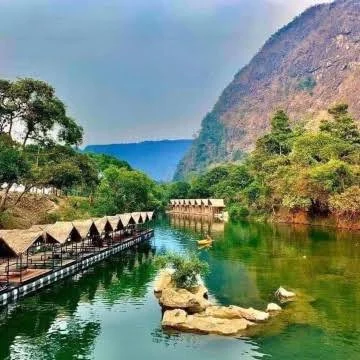
01 · THE RIVER
Tha Falang is a swimming stop first, not another cave to tick off
Tha Falang sits east of Thakhek along the Route 12 cave corridor, with current sources placing it roughly 12–16 kilometres from town depending on the reference point used. The attraction is a clear river bend framed by limestone cliffs and vegetation. Provincial tourism currently lists the natural site as free to enter and open daily around 08:00–17:00. Other current tourism material extends the published closing time to 18:00, which is a good reminder that operating arrangements should be checked on the day rather than treated as permanent. In the dry season, lower water and better clarity make the river especially attractive for swimming. In wetter periods, the water rises and the short access road can become less predictable. Read the river before jumping in, use daylight hours, and do not assume that a calm photograph from another month represents today’s current.
The correct first question is not “where do I jump?” but “what is the river doing today?”
02 · FROM FRENCH PIER TO LOCAL LEISURE SITE
The name remembers the colonial period, but the place now belongs to a much wider local tourism culture
Khammouane Tourism links the name Tha Falang to the French colonial period, when French officials and explorers reportedly used the site to swim and relax; “falang” remains the everyday Lao word for a Westerner or foreigner. That history explains the name, but it should not freeze the place in a colonial anecdote. A 2024 Vientiane Times report described Tha Falang as a major domestic and cross-border leisure destination receiving about 300 visitors a day at that time, with roughly 60 percent arriving from Thailand. The nearby Third Lao–Thai Friendship Bridge makes day trips from Nakhon Phanom practical. Weekends can therefore feel less like a hidden backpacker swimming hole and more like a busy regional picnic and family destination — which is part of the real modern identity of the place.
Tha Falang is not “secret Laos”. On a busy weekend, local leisure culture is the experience.
03 · SWIM, EAT OR STAY
The riverbank has grown into a small leisure base
Current reporting describes much more infrastructure than the old image of an empty river bend: riverside food, floating or bamboo seating, fish feeding, camping, kayaking and accommodation. The Vientiane Times reported 36 rooms and a camping area able to host around 100 people in late 2024, together with kayaking along a calm five-kilometre stretch of river. Recent independent Loop travellers also describe renting a riverside hut, eating local fish and staying overnight. These commercial services should be kept separate from the free natural-site access: a hut, meal, kayak or room can cost money without turning the river itself into a paid attraction. If you are only stopping to swim, a couple of hours is enough. If you want lunch, a kayak or sunset, let the stop expand naturally rather than racing back to Route 12.
Swim, eat, watch the limestone and let the Route 12 schedule wait.
04 · PLACE IT INSIDE CAVE ALLEY
Tha Falang works best between caves because it changes the rhythm of the road
The official Khammouane Loop itinerary places Tha Falang on Day 1, in the same Route 12 corridor as Elephant Cave, Xiang Liap and Nang Aen. That is exactly where it makes sense. After stone, stairs and dark chambers, the river gives the day a completely different physical rhythm: swim, eat, sit down and cool off before continuing east. A short countryside mini-loop beyond Tha Falang is also documented by recent riders, using compact dirt roads through villages and karst scenery before reconnecting with the main route. Keep swimwear and a towel accessible rather than buried under all your Loop luggage, carry cash for local services, and choose water shoes or sandals if you plan to move over rocky banks. In heavy rain, reconsider swimming and the dirt-road detour even if the main highway remains easy.
FIELD NOTE · BEFORE YOU LEAVE
What matters more than another pin
Tha Falang is the first Loop day’s reset button: clear river water under limestone cliffs, local leisure culture, food and kayaking make it a place to stop moving for a while rather than another attraction to photograph from the bike.
Tha Falang is where the first Loop day stops being a list of caves. Swim, eat, watch the limestone and let the road wait.
PLAN THE VISIT
Tha Falang, practically
The useful details in one place before you leave Thakhek.
From Thakhek
Current sources place Tha Falang roughly 12–16 km east or northeast of central Thakhek along the Route 12 cave corridor. Follow the signed turn from the main road and continue on the short local access road to the river.
Hours & access
Khammouane Tourism currently lists daily hours around 08:00–17:00 and free entrance to the natural site. Other current tourism listings extend the closing time to 18:00, so reconfirm locally if arriving late.
Swimming season
November to April generally brings clearer, lower water and the easiest swimming conditions. Rainy-season levels can rise significantly and the access road can become more difficult; always read the current before entering.
What is available
Recent reporting documents swimming, riverside meals, fish feeding, camping and kayaking, including a calm stretch of river used for longer paddling. Accommodation and bamboo or floating seating are also available around the developed riverbank.
Budget
Keep free natural-site access separate from paid services. Food, a riverside hut, kayak, camping or accommodation may cost extra even when there is no general entrance fee.
What to bring
Keep swimwear and a towel accessible, bring cash, drinking water and sun protection, and use sandals or water shoes around rocky banks. Weekdays and mornings are better if you prefer a quieter stop.
QUESTIONS BEFORE GOING
Tha Falang, without the guesswork
Short answers built from the practical field information already attached to this landmark.
From Thakhek?
Current sources place Tha Falang roughly 12–16 km east or northeast of central Thakhek along the Route 12 cave corridor. Follow the signed turn from the main road and continue on the short local access road to the river.
Hours & access?
Khammouane Tourism currently lists daily hours around 08:00–17:00 and free entrance to the natural site. Other current tourism listings extend the closing time to 18:00, so reconfirm locally if arriving late.
Swimming season?
November to April generally brings clearer, lower water and the easiest swimming conditions. Rainy-season levels can rise significantly and the access road can become more difficult; always read the current before entering.
What is available?
Recent reporting documents swimming, riverside meals, fish feeding, camping and kayaking, including a calm stretch of river used for longer paddling. Accommodation and bamboo or floating seating are also available around the developed riverbank.
Budget?
Keep free natural-site access separate from paid services. Food, a riverside hut, kayak, camping or accommodation may cost extra even when there is no general entrance fee.
KEEP EXPLORING LAOS
Where does the road go next?
Four other field notes that connect naturally with this part of the trip.


Field note method. Wikipedia is used as a research starting point for history and geography when a relevant article exists. Facts are checked against official, local or specialist sources where possible. Independent travel blogs and field reports are used to identify practical questions, recurring observations and traveller perspective; their wording is not copied.
Sources & photo licences
Source links for this field note are being consolidated.
Photo author, Wikimedia Commons attribution, licence and the exact file source are also shown directly under each Commons image.
KEEP IT IN THE NOTEBOOK
Save Tha Falang for the road.
Add this landmark to your trip now, or open the map when you are ready to work out the route.