
Capital notes
Vientiane
Mekong · Lan Xang · national capital
A city field guide to the Mekong, Lan Xang history, That Luang, the riverfront and the practical role of the Lao capital.
- 01A low-rise capital stretched along a bend in the Mekong
- 02The capital has been moved, destroyed and rebuilt more than once
- 03That Luang is central to Laos, even without World Heritage status
- 04Lane Xang Avenue connects monuments with the modern capital
01 · Read the capital
A low-rise capital stretched along a bend in the Mekong
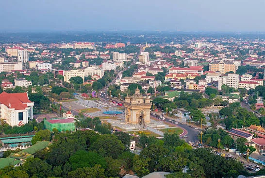
Vientiane is organised less around one dense centre than around a sequence of districts and avenues. The old riverfront, Nam Phou area, temple streets and markets form the easiest first chapter, while national monuments, embassies and newer commercial areas spread farther inland.
That scale explains the city’s unusual rhythm. It is possible to spend an evening walking beside the Mekong and still need wheels the next morning for Patuxay, That Luang, the railway station or an outer administrative district.
02 · Lan Xang and reconstruction
The capital has been moved, destroyed and rebuilt more than once
Vientiane became an important Lan Xang centre in the sixteenth century, when King Setthathirath moved the royal capital here. The city was heavily damaged after Siamese forces captured and destroyed much of it in 1828, leaving only fragments of the earlier urban fabric.
Under French colonial administration, Vientiane was rebuilt as the capital of Laos. That layered history explains why Buddhist monuments, colonial-era civic buildings and broad twentieth-century avenues coexist rather than forming one continuous old town.
03 · The national symbol
That Luang is central to Laos, even without World Heritage status
Pha That Luang is one of the defining religious and national symbols of Laos. UNESCO’s tentative-list record describes the present monument as having been built in 1566 under King Setthathirath, with a tall central stupa surrounded by lower elements and a cloistered enclosure.
There is an important distinction worth keeping clear: That Luang has been on Laos’s UNESCO Tentative List since 1992, but it is not currently inscribed on the World Heritage List. Its significance does not depend on a UNESCO badge; it comes from the role it plays in Lao Buddhist and national identity.


04 · The city axis
Lane Xang Avenue connects monuments with the modern capital
From the central city, Lane Xang Avenue draws the eye toward Patuxay and continues into the broader government and monument district. Patuxay itself is a twentieth-century memorial whose monumental scale contrasts sharply with the quieter temple courtyards closer to the river.
This axis is useful for understanding Vientiane spatially. Rather than hopping between isolated attractions, follow the avenue, pause at Patuxay, then continue toward That Luang or branch into nearby neighbourhoods.
05 · Temples and memory
The smaller temple courtyards carry the city’s most intimate history
Wat Sisaket, Haw Phra Kaew, Wat Ong Teu and other central religious sites create a quieter historical route than the monumental avenue. Their value comes from architecture, sculpture, active worship and the way Buddhist life remains embedded in the centre of the capital.
Vientiane also holds a very different national memory through the COPE Visitor Centre, which explains the continuing human impact of unexploded ordnance in Laos. Visiting temples and COPE in the same city chapter reveals two very different pieces of Lao history without forcing them into the same story.
06 · After the heat
The riverfront explains Vientiane better in the evening
Late afternoon pulls walkers, exercise groups, food sellers and market stalls toward the Mekong. The city becomes more social as the heat drops, and the riverfront works best as a flexible evening rather than a formal attraction with a fixed beginning and end.
The visible riverbank changes with the season, and the Thai side can feel surprisingly close. Walk first, then choose a market, food stall, café or riverside table according to what the evening looks like rather than chasing one exact pin.
07 · The practical capital
Airport, railway, border and embassies make Vientiane a travel hinge
Wattay International Airport sits comparatively close to the central city. The Laos–China Railway station is much farther out and requires a separate road transfer, while the Thai–Lao Friendship Bridge connects the wider capital area with Nong Khai in Thailand.
Vientiane also concentrates embassies, larger hospitals, banks and specialist services that are harder to find elsewhere in Laos. That makes it a useful place to solve practical problems—but appointments, lunch closures, traffic and document requirements can still turn a simple errand into half a day.
08 · Setting the pace
Two days show the capital; a third lets it stop being an errand
Two nights allow a central temple walk, Patuxay, That Luang and one Mekong evening without rushing. A third day creates room for COPE, cafés, markets, a museum, paperwork or simply a slower route through the neighbourhoods between the landmarks.
Vientiane is also a launch point. Vang Vieng and Luang Prabang sit on the railway corridor, Thailand lies across the Mekong, and Pakse begins a much longer southern chapter. Build the onward journey around the terminal you actually use rather than a generic idea of “leaving Vientiane”.
Railway procedures, border rules, embassy requirements, transport terminals and opening hours can change. Use the guide for context, then confirm anything tied to a fixed connection or official appointment.
Sources & further reading
BACK TO THE CITY
Start exploring Vientiane
Keep these notes as context, then return to Vientiane for landmarks, addresses and the practical side of the stay.